Wasted Heat as Northern Commons: Hot Spots in the Square
Last week’s post, An ethics of surplus and the right to waste?: Discards and Degrowth, asked about a different ethics of surplus and wasting, particularly in terms of the values we would like to bring to wasting: “The different patterns of excess energy use [or wasting] characterize and distinguish different types of societies across space and time. Excess can be spent on sacrifice or festival, in war or in peace. … How should we go about the removal of the problem of energy and excess?” (D’Alisa 2004, 87). How should we waste? What would a good form of wasting look like? This post offers some ideas in that direction by looking at how wasted heat might support a commons.
The following post is based on research conducted by undergraduate students at the Memorial University of Newfoundland in northeastern Canada. Mapping heat leaks in a public place was seen as a way to facilitate outdoor public gathering places for civic life–commons–or at least to provide public “hot spots” for people waiting for buses, busking, or otherwise staying outdoors. The report has been edited to fit the format and topic of this blog, but you can read the full report here.

The Firelog Collective in action. Photo Creative Commons via Grace Akese, Juls Mack & David Mandville.
Hot Spots in the Square: Reclaiming and Relocating the Commons through the Mapping of Relative Heat Differences in an Urban Outdoor Space
Grace Akese, Juls Mack & David Mandville
The Firelog Collective
![]()
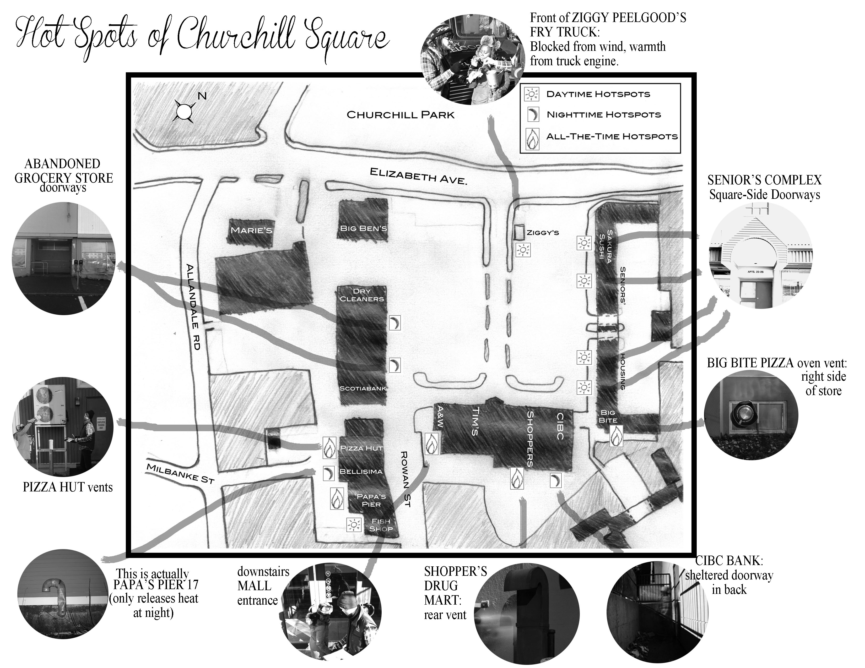
Research Problem: How can we make relative temperature differences visible to the naked eye, and why is this important in the Newfoundland context? A distinct characteristic of outport Newfoundland communities is common space. Rooted in the medieval open-field system, the Commons is shared public resources open for anyone to use. Our project aims to unveil the potential for the Commons within the outdoor urban infrastructure of Churchill Square in St. John’s, Newfoundland, by locating relative heat differences—that is, we wanted to find out which areas in the Square provided a bit of warmth during the long, cold winter. Locating these “hot spots” lets us imagine the possibility of public congregation or reclaimed community space.
Methodology: To measure heat increases and locate these hot spots, we used a do-it-yourself, open-source thermal flashlight using instructions from Public Lab. This flashlight uses a non-contact infrared sensor to measure heat differences. Temperatures above and below pre-programmed levels are indicated with a red light for high temperatures and a blue light for low temperatures. Middle-range temperatures are green.

Image produced with a Thermal Flashlight by the Firelog Collective. Hotter areas are red, and colder areas are blue. Green indicates the mid-range of temperature. Conclusion: the vent is expelling warm air. Creative Commons Attribution-NonCommercial-ShareAlike 4.0 International License.
Because of vast daily temperature fluctuations in St. John’s, and how outside temperatures would affect heat changes within the hotspots, we operationalized our temperature measurements by using a mathematical equation that can be used when the temperature is between +17°C and -13.4°C
Main findings: We did three different field work sessions, both day and night, in various weather conditions. Our flashlight had red (warm) readings at the following spots:
Literature review and Problem Background:
Newfoundland Folklorist Gerald Pocius (1991) identifies The Commons as a distinct feature of Newfoundland outport communities. Drawing on his ethnographical work on Calvert, on the Southern Shore, Pocius writes that this form of land division, “exhibiting the vestiges of the medieval open-field system, ” (p. 124), meant that a prominent characteristic of the landscape of the outport community is land not owned by any particular person but is used by whomever needs it at any article time. This includes common grazing lands, where animals owned by various people intermingle, agricultural land which changes hands every season, or berries and fish, which require skill to acquire but are equally open for any resident to have his or her hand at. Pocius writes that even if land is known to be owned by a particular family, if unused it will uncontroversially be taken up for use by someone else, “so as not to be ‘wasted’” (p. 134).
Using this notion that immediately uninhabited space has the potential for waste and should be open for community reclamation at any point in time, we sought to map a nearby urban area, Churchill Square. Churchill Square was of particular interest to us because a “town square” is usually a pedestrian area for community gatherings surrounded by small shops. Churchill Square does have an array of small shops and restaurants, seemingly more diverse than other shopping areas in St. John’s. Given the geographical features of St. John’s that create inhospitable weather conditions, we aimed to map the invisible thermal infrastructure of Churchill Square.
This urban mapping project builds on renewed academic interest in public spaces, especially in urban areas from critical urban geographers, cultural theorist, and artists who claim that we should rethink what these spaces are and have come to be. There is also growing public discourse on public spaces stemming from issues of increasing homeless people on streets, a crisis of common areas in cities, increasing commercialization/privatization of public spaces, violence against women in public spaces, and security technologies in these spaces (Mitchell, 1996). Our project is largely informed by the idea that the city is something in the ‘making’ (Simone, 2011), and that urban spaces are constituted by the subjects and socialites of the people who live in it and as an assemblage of human and nonhuman interactions (Amin 2008; Latour & Hermant 1998). That is, we can configure how the urban is experienced/done and we can ‘do’ public spaces in diverse ways. Using the flashlight to measure heat differences, we located and mapped hotspots in the Churchill square area of St John’s. These hotspots we believe expand the community use of the Churchill square area. More importantly and from a social justice perspective, it allows privately owned infrastructure to be used in diverse ways by a broader spectrum of people, particularly for shelter and warmth. In this way, heat leaks and “waste” heat are not an inherently bad things, but become the potential basisi of a common good.
Methodology:

Works cited
D’Alisa, G., Demaria, F., & Kallis, G. (Eds.). (2014). Degrowth: A vocabulary for a new era. Routledge.
Gerald L. Pocius. (1991). A place to belong: Community order and everyday space in Calvert, Newfoundland. McGill-Queen’s Press-MQUP.
![]() This research and writing by Grace Akese, Juls Mack & David Mandville is licensed under a Creative Commons Attribution-NonCommercial-ShareAlike 2.0 Generic License.
This research and writing by Grace Akese, Juls Mack & David Mandville is licensed under a Creative Commons Attribution-NonCommercial-ShareAlike 2.0 Generic License.
One thought on “Wasted Heat as Northern Commons: Hot Spots in the Square”
Comments are closed.

Cool project! Very creative and resourceful!